The ocean floor holds countless secrets, and advanced sonar technology is revolutionizing how we discover and document shipwrecks hidden beneath the waves.
🌊 The Evolution of Underwater Detection Technology
For centuries, locating shipwrecks was a matter of chance, luck, and often divine intervention. Fishermen would snag their nets on mysterious underwater objects, divers would stumble upon remnants of maritime disasters, and treasure hunters would rely on historical accounts that were frequently inaccurate or deliberately misleading. The advent of sonar technology fundamentally changed this landscape, transforming underwater archaeology from a game of chance into a precise science.
Modern sonar systems have evolved dramatically from their primitive predecessors used during World War II. Today’s cutting-edge equipment can penetrate murky waters, reach extraordinary depths, and create three-dimensional images of underwater landscapes with remarkable clarity. This technological leap has opened new frontiers in maritime archaeology, environmental conservation, and even modern shipping safety.
Understanding How Advanced Sonar Systems Work
Sonar, an acronym for Sound Navigation and Ranging, operates on a deceptively simple principle: sound waves travel through water, bounce off objects, and return to the source. However, the sophistication lies in how modern systems interpret these returning signals. Contemporary sonar technology employs multiple frequencies simultaneously, allowing researchers to gather different types of information in a single pass.
High-frequency sonar provides exceptional detail for smaller objects and surface features, while low-frequency systems penetrate deeper into sediment layers, revealing structures buried beneath the ocean floor. This dual-capability approach has proven invaluable when searching for ancient wrecks that may be partially or completely covered by centuries of marine sediment accumulation.
Multibeam Sonar: The Game-Changer in Wreck Detection
Multibeam sonar systems represent perhaps the most significant advancement in underwater mapping technology. Unlike traditional single-beam sonar that scans one line at a time, multibeam systems emit dozens or even hundreds of sonar beams simultaneously, creating a wide swath of coverage with each pass. This technology can map vast areas of seafloor in remarkably short timeframes.
The resolution achieved by modern multibeam systems is nothing short of extraordinary. Researchers can now detect objects as small as a few centimeters across, even at depths exceeding several thousand meters. This precision has led to the discovery of wrecks that previous technologies would have missed entirely, particularly those in challenging deep-water environments.
⚓ Notable Discoveries Powered by Advanced Sonar
The past two decades have witnessed an explosion of significant shipwreck discoveries, many of which would have remained hidden without cutting-edge sonar technology. These findings have rewritten historical narratives, solved centuries-old mysteries, and provided unprecedented insights into maritime history.
One remarkable example involves the discovery of HMS Erebus and HMS Terror, the two ships lost during Sir John Franklin’s ill-fated 1845 Arctic expedition. Using a combination of side-scan sonar and multibeam systems, researchers located these vessels in Canadian Arctic waters after more than 160 years of searching. The wrecks were found in remarkably good condition, preserved by the cold Arctic waters.
Deep-Water Discoveries That Rewrote History
The deep ocean presents unique challenges for wreck detection, but also offers exceptional preservation conditions. Ships that sink to great depths often remain in extraordinary condition due to the absence of wood-boring organisms, minimal currents, and stable temperatures. Advanced sonar technology has made these deep-water sites accessible to researchers without the need for risky manned submersible missions.
The discovery of the SS Gairsoppa, a British cargo ship torpedoed during World War II, demonstrates the potential of modern sonar systems. Located at a depth of nearly 5,000 meters, the wreck was carrying a cargo of silver worth hundreds of millions of dollars. The precision mapping provided by autonomous underwater vehicles equipped with advanced sonar made recovery operations possible in conditions that would have been unthinkable just decades earlier.
🔍 The Technology Behind Modern Wreck Detection
Today’s wreck-hunting expeditions employ an integrated suite of technologies that work in concert to locate, identify, and document underwater sites. The process typically begins with broad-area surveys using ship-mounted multibeam sonar systems, which can cover hundreds of square kilometers per day.
Once potential targets are identified, researchers deploy more specialized equipment for detailed investigation. Side-scan sonar provides photograph-like images of the seafloor, revealing the shape and orientation of potential wrecks. Synthetic aperture sonar takes this a step further, using advanced processing algorithms to create even sharper images by combining data from multiple sonar pings.
Autonomous Underwater Vehicles: The New Explorers
Autonomous Underwater Vehicles, commonly known as AUVs, have revolutionized deep-water exploration. These robotic submarines can operate independently for days at a time, following pre-programmed search patterns while collecting high-resolution sonar data. Unlike remotely operated vehicles that require constant human control via tethering cables, AUVs navigate using sophisticated onboard computers and inertial navigation systems.
Modern AUVs carry multiple sonar systems simultaneously, along with cameras, magnetometers, and other sensors. This multi-sensor approach allows researchers to gather comprehensive data about potential wreck sites in a single deployment. The vehicles can operate at depths and in conditions that would be extremely dangerous or impossible for human divers, expanding the searchable area exponentially.
Overcoming Challenges in Wreck Detection
Despite technological advances, locating shipwrecks remains a challenging endeavor. The ocean covers more than 70 percent of Earth’s surface, and much of this vast expanse remains unexplored. Even with sophisticated sonar systems, searchers must know approximately where to look, making historical research an essential component of any wreck-hunting expedition.
Environmental factors also complicate detection efforts. Strong currents, varying water temperatures, and differing salinity levels can all affect sonar performance. Additionally, wrecks often become colonized by marine life or covered by sediment, changing their acoustic signature and making them difficult to distinguish from natural geological features.
Distinguishing Wrecks from Natural Features
One of the most persistent challenges in wreck detection involves differentiating between actual shipwrecks and natural rock formations or other seafloor features. Experienced sonar operators learn to recognize certain characteristics that suggest human-made objects: straight lines, right angles, repetitive patterns, and geometric shapes that rarely occur in nature.
Advanced processing software now incorporates artificial intelligence algorithms trained on thousands of known wreck images. These systems can automatically flag potential targets for human review, dramatically reducing the time required to analyze survey data. Machine learning continues to improve these systems’ accuracy, though human expertise remains essential for final identification.
📊 Comparing Sonar Technologies for Wreck Detection
| Technology Type | Best Use Case | Typical Depth Range | Resolution Quality |
|---|---|---|---|
| Multibeam Sonar | Wide-area surveys | 10-11,000 meters | Medium to High |
| Side-scan Sonar | Detailed imaging | 0-1,000 meters | Very High |
| Synthetic Aperture Sonar | Ultra-detailed analysis | 50-3,000 meters | Extremely High |
| Sub-bottom Profiler | Buried object detection | 0-500 meters | Medium |
🗺️ Creating 3D Models from Sonar Data
Once sonar data has been collected, the next step involves processing this information into usable formats. Modern software can transform raw sonar returns into stunning three-dimensional models that allow researchers to virtually explore wreck sites before ever sending down a camera or diver. These models serve multiple purposes, from planning archaeological excavations to creating public exhibits that bring maritime history to life.
The level of detail achievable in these digital reconstructions is remarkable. Researchers can identify specific features such as deck arrangements, cargo holds, weaponry, and even damage patterns that reveal how a ship met its end. In some cases, the sonar-derived models are so precise that naval architects can determine a vessel’s exact specifications and compare them against historical records.
Integration with Photogrammetry and ROV Footage
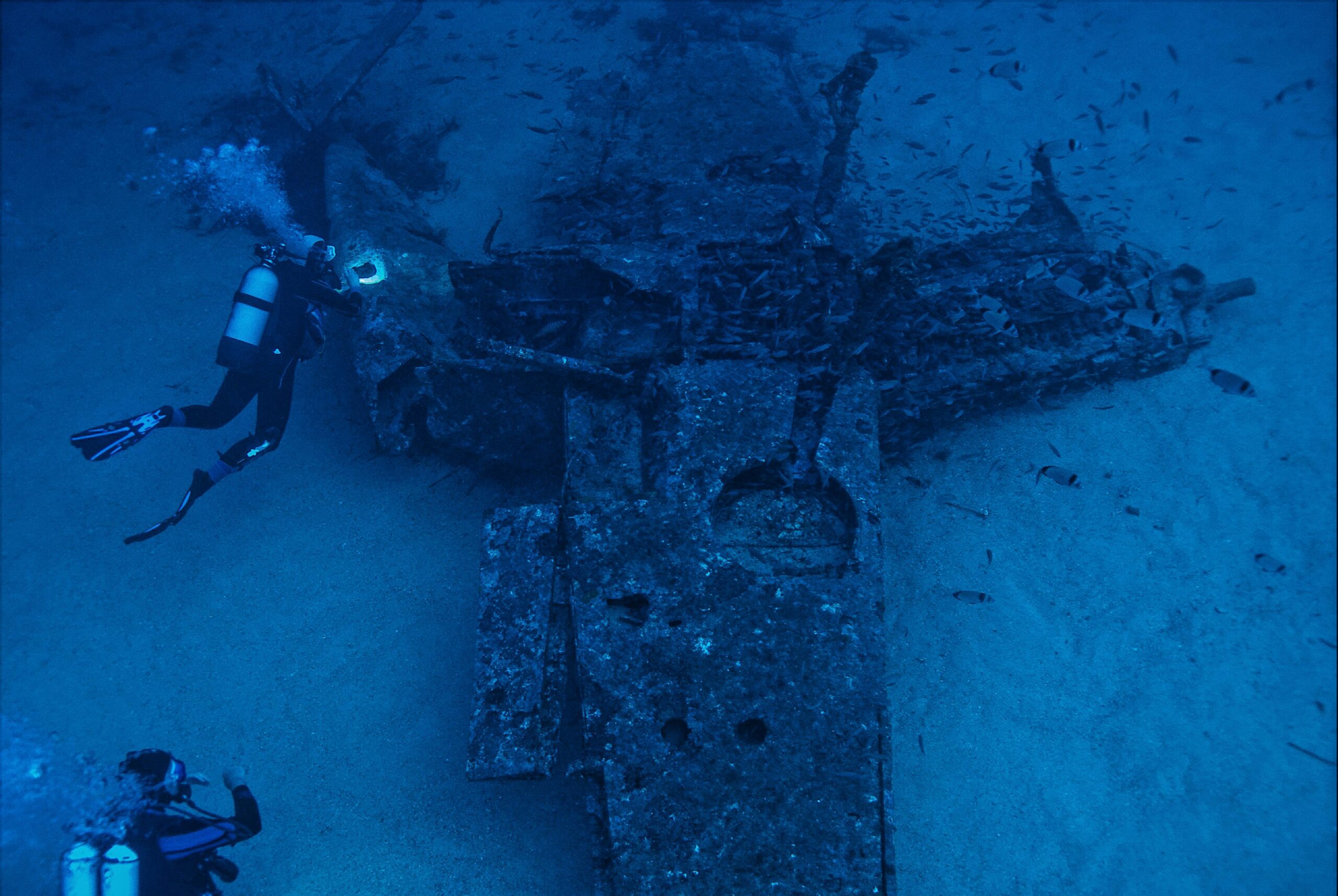
While sonar provides the foundational framework for understanding wreck sites, combining this data with optical imagery creates even more comprehensive documentation. Remotely operated vehicles equipped with high-definition cameras can capture detailed photographs and video footage, which are then integrated with sonar models using photogrammetry techniques.
This multi-modal approach yields extraordinarily detailed virtual representations of wreck sites. Archaeologists can take measurements, test hypotheses, and plan interventions without disturbing the actual site. For wrecks located at extreme depths or in hazardous conditions, these virtual models may represent the only way researchers can “visit” and study the sites.
Environmental and Archaeological Considerations
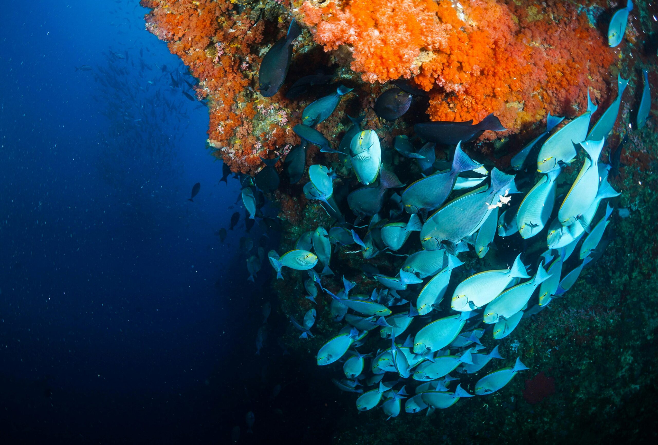
The discovery of shipwrecks raises important questions about preservation, heritage protection, and environmental stewardship. Many wrecks serve as artificial reefs, supporting complex ecosystems that have developed over decades or centuries. Disturbance of these sites, even for archaeological purposes, can have unintended ecological consequences.
Modern wreck detection projects increasingly incorporate environmental impact assessments into their planning processes. Non-invasive sonar surveys allow researchers to document sites comprehensively without physical intervention, preserving both the archaeological resource and the surrounding ecosystem. This approach aligns with contemporary best practices in underwater cultural heritage management.
Legal and Ethical Frameworks for Wreck Exploration
International waters present complex jurisdictional questions regarding who has the right to explore, document, or recover artifacts from shipwrecks. Various international conventions and national laws govern these activities, with varying degrees of enforcement. The UNESCO Convention on the Protection of Underwater Cultural Heritage provides a framework for responsible wreck exploration, emphasizing in-situ preservation and discouraging commercial exploitation.
Advanced sonar technology has made it possible to locate wrecks far from any nation’s territorial waters, complicating these legal questions. Ethical exploration teams work closely with appropriate governmental and cultural authorities to ensure that discoveries are properly documented, protected, and, when appropriate, made accessible to researchers and the public.
🚀 The Future of Wreck Detection Technology
The field of underwater sonar technology continues to evolve at a rapid pace. Emerging innovations promise even greater capabilities for detecting and documenting hidden wreck sites. Quantum sensing technologies, still in experimental stages, could potentially detect minute variations in magnetic and gravitational fields caused by buried wrecks, even when they’re completely concealed beneath sediment layers.
Swarm robotics represents another frontier in wreck detection. Instead of deploying single AUVs, future expeditions might release coordinated fleets of small, inexpensive robots that work collectively to survey vast areas. These swarms could adapt their search patterns in real-time based on findings, focusing resources on the most promising areas while maintaining broad coverage.
Artificial Intelligence and Predictive Modeling
Machine learning algorithms are becoming increasingly sophisticated at predicting likely wreck locations based on historical shipping routes, weather patterns, military engagement records, and other data sources. By analyzing thousands of variables simultaneously, these systems can generate probability maps that guide search efforts, dramatically improving the efficiency of detection operations.
As these AI systems are exposed to more data from successful discoveries, their predictive accuracy continues to improve. Future wreck hunters may begin their searches with detailed probability maps that narrow potential search areas from hundreds of thousands of square kilometers to manageable zones that can be thoroughly surveyed in days or weeks rather than years.
Citizen Science and Crowdsourced Discovery
An unexpected development in wreck detection involves the democratization of exploration through citizen science initiatives. Projects like the Global Exploration Portal allow volunteers to examine sonar imagery and flag potential anomalies for expert review. This crowdsourced approach has already led to several significant discoveries and engages the public directly in the exploration process.
Educational institutions and museums are increasingly offering virtual access to sonar datasets, creating opportunities for students and amateur historians to participate in genuine research. These initiatives serve dual purposes: they help process the enormous volumes of data generated by modern surveys while fostering public interest in maritime archaeology and ocean exploration.
⚡ Technological Synergies Driving Innovation
The most exciting developments in wreck detection often emerge from unexpected technological convergences. Advances in battery technology originally developed for electric vehicles enable AUVs to operate for longer periods at greater depths. Improvements in data compression algorithms from the telecommunications industry allow researchers to process and transmit larger sonar datasets more efficiently.
Cloud computing and collaborative platforms mean that experts from around the world can simultaneously examine newly collected sonar data, bringing diverse perspectives to interpretation challenges. This global collaborative approach accelerates the identification process and reduces the likelihood of missing significant discoveries hidden in complex datasets.
Preserving Maritime Heritage for Future Generations
Beyond the excitement of discovery, advanced sonar mapping serves a crucial preservation function. Many historic wrecks are deteriorating due to corrosion, biological activity, and increasingly, ocean acidification linked to climate change. High-resolution sonar surveys create permanent digital records of these sites, preserving them in virtual form even if the physical remains eventually disintegrate.
These digital archives represent an invaluable resource for future researchers, who may have access to analytical tools and techniques not yet invented. By capturing wreck sites in extraordinary detail today, current researchers ensure that tomorrow’s archaeologists can continue to extract new insights from these underwater time capsules.
The Human Element in Technological Exploration
Despite remarkable technological advances, human expertise remains irreplaceable in wreck detection and interpretation. Experienced marine archaeologists bring contextual understanding that no algorithm can replicate, recognizing subtle clues in sonar data that might indicate cultural significance. The most successful exploration projects blend cutting-edge technology with deep historical knowledge and experienced professional judgment.
Training the next generation of underwater archaeologists requires familiarity with both traditional archaeological methods and emerging technological capabilities. Universities and research institutions are adapting their curricula to ensure that future professionals can effectively leverage advanced sonar systems while maintaining the rigorous analytical standards that define quality archaeological research.
The ongoing revolution in sonar technology continues to unveil the deep’s hidden secrets, bringing lost vessels and forgotten maritime histories back into human consciousness. As systems become more sophisticated, more accessible, and more powerful, we can anticipate a golden age of underwater discovery that will dramatically expand our understanding of human seafaring history and the countless stories resting beneath the waves. Each new wreck discovered adds another piece to the vast puzzle of maritime heritage, reminding us that our planet still holds innumerable mysteries waiting to be revealed by those with the courage, curiosity, and technological capability to seek them out.

Toni Santos is a maritime researcher and underwater archaeologist specializing in the study of submerged heritage, ancient port systems, and the cultural landscapes preserved beneath the sea. Through an interdisciplinary and immersive approach, Toni investigates how humanity has left traces of knowledge, commerce, and legend in the underwater world — across oceans, myths, and sunken cities.
His work is grounded in a fascination with wrecks not only as artifacts, but as carriers of hidden meaning. From historic shipwreck discoveries to mythical harbors and lost coastal settlements, Toni uncovers the physical and cultural evidence through which civilizations preserved their relationship with the maritime unknown.
With a background in marine archaeology and underwater survey methods, Toni blends technical analysis with archival research to reveal how oceans were used to shape identity, transmit memory, and encode sacred knowledge.
As the creative mind behind revaltro, Toni curates documented dive studies, speculative harbor maps, and archaeological interpretations that revive the deep cultural ties between water, folklore, and forgotten science.
His work is a tribute to:
The submerged heritage of Historic Shipwrecks and Their Cargoes
The legendary sites of Mythical Harbors and Lost Civilizations
The technical methods of Underwater Exploration Techniques
The natural archiving power of Preservation in Salt and Sediment
Whether you’re a maritime historian, nautical researcher, or curious explorer of forgotten submerged worlds, Toni invites you to explore the hidden depths of oceanic heritage — one wreck, one harbor, one legend at a time.