The ocean floor holds countless mysteries, and modern 3D scanning technology is transforming how we explore and document underwater environments with unprecedented precision.
🌊 A New Era of Ocean Exploration
For centuries, humanity has been captivated by the secrets hidden beneath the waves. From sunken ships carrying historical treasures to ancient civilizations swallowed by rising seas, the underwater world represents one of our planet’s last frontiers. Traditional underwater exploration methods have long been limited by visibility constraints, depth restrictions, and the inherent challenges of working in hostile aquatic environments. However, cutting-edge 3D scanning technology is revolutionizing how researchers, archaeologists, and marine scientists document and study submerged landscapes.
The integration of advanced scanning systems with modern diving equipment and remotely operated vehicles (ROVs) has opened new possibilities for underwater discovery. These technologies create detailed digital representations of underwater sites, allowing researchers to analyze structures, artifacts, and geological formations with millimeter-level accuracy without disturbing delicate ecosystems or historical sites.
Understanding Underwater 3D Scanning Technology
Underwater 3D scanning employs various technological approaches to capture the shape, texture, and spatial relationships of submerged objects and environments. Unlike terrestrial scanning, underwater applications must contend with unique challenges including light absorption, water turbidity, pressure variations, and the constant motion caused by currents.
Primary Scanning Technologies
Several core technologies form the foundation of underwater 3D scanning systems. Photogrammetry remains one of the most accessible and widely used methods, utilizing overlapping photographs taken from multiple angles to construct three-dimensional models. Advanced algorithms process these images to identify common reference points and calculate spatial relationships, ultimately generating detailed digital replicas.
Structured light scanning projects patterns of light onto underwater surfaces and uses cameras to capture how these patterns deform across irregular surfaces. This deformation data allows sophisticated software to calculate precise depth measurements and create accurate 3D models. While highly effective in controlled environments, this technology faces limitations in turbid water or areas with significant ambient light variation.
Laser scanning systems, adapted for underwater use, emit concentrated light beams that reflect off surfaces back to sensors. By measuring the time delay between emission and reception, these systems calculate distances with extreme precision. Modern underwater laser scanners can operate at considerable depths and maintain accuracy even in challenging visibility conditions.
Acoustic scanning technologies, particularly multibeam sonar systems, use sound waves rather than light to map underwater terrain. Since sound travels more effectively through water than light, acoustic methods excel at covering large areas and working in complete darkness or extreme turbidity where optical systems fail.
Archaeological Treasures Rising from the Depths 🏛️
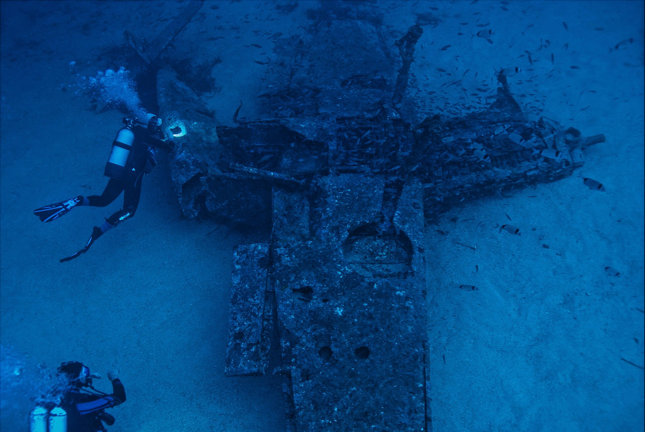
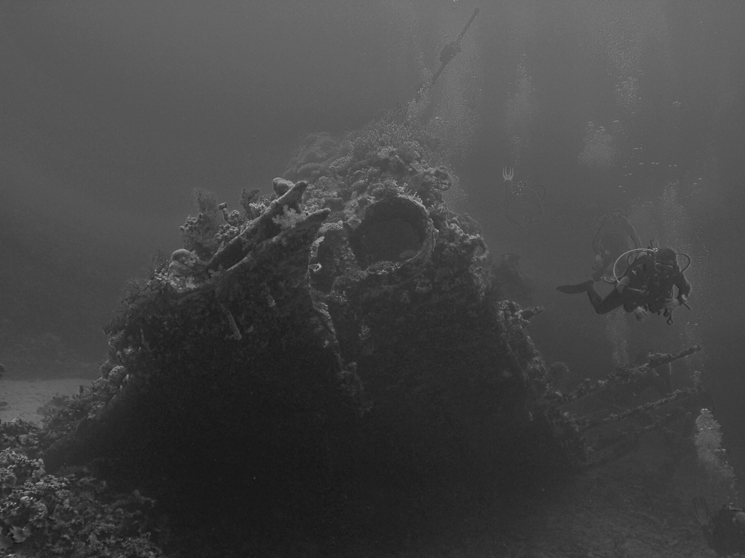
Underwater archaeology has experienced a renaissance thanks to 3D scanning technology. Ancient shipwrecks that once required years of painstaking manual documentation can now be comprehensively mapped in weeks or even days. These digital records preserve the exact state of archaeological sites at the moment of scanning, creating permanent archives that researchers can study long after physical sites have degraded or been disturbed.
The documentation of the Antikythera wreck, site of the famous ancient Greek analog computer, demonstrates the power of modern scanning techniques. Researchers created detailed 3D models of the shipwreck site, revealing previously unknown artifacts hidden beneath sediment and coral growth. These models enabled archaeologists to plan excavations with unprecedented precision, minimizing damage to the site while maximizing scientific return.
Preserving Cultural Heritage Digitally
Submerged cities and settlements provide invaluable insights into past civilizations and changing sea levels throughout history. Sites like Pavlopetri in Greece, believed to be one of the oldest submerged cities in the world, have been comprehensively scanned to create detailed digital twins. These virtual replicas allow researchers worldwide to study the site’s layout, architecture, and structural details without physical travel or the environmental impact of repeated diving expeditions.
Digital preservation through 3D scanning also serves as insurance against natural deterioration, human interference, or climate change impacts. As ocean acidification and warming waters accelerate the degradation of underwater cultural heritage sites, having accurate digital records becomes increasingly critical for future generations.
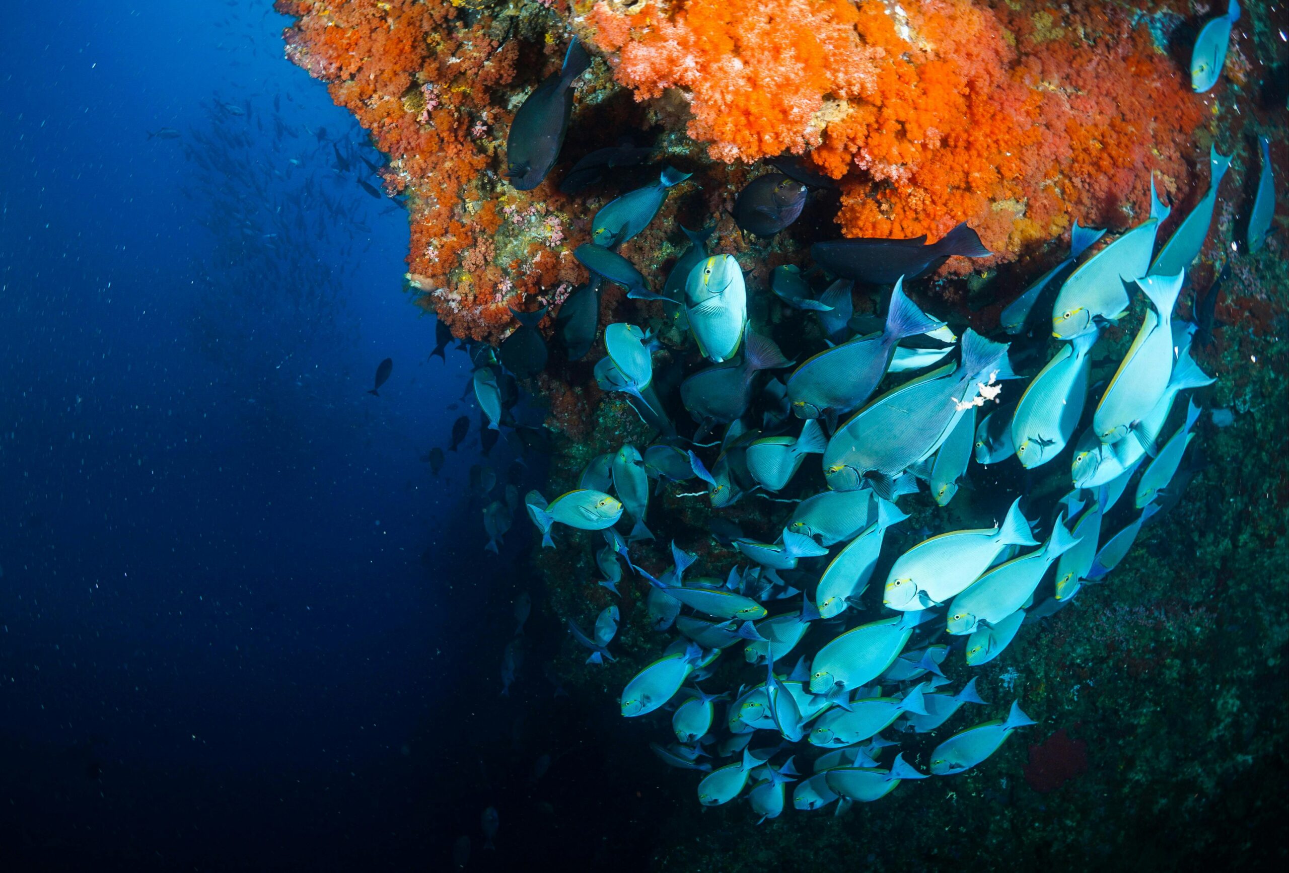
Marine Biology and Ecosystem Monitoring
Beyond archaeology, 3D scanning technology provides marine biologists with powerful tools for studying underwater ecosystems. Coral reefs, among the most biodiverse and threatened ecosystems on Earth, benefit tremendously from detailed 3D documentation that tracks changes over time.
Researchers can now create baseline scans of reef systems and return periodically to document growth, bleaching events, storm damage, or recovery patterns. The three-dimensional nature of these scans captures the complex structural complexity that two-dimensional photography misses, providing crucial data about habitat availability for reef-dwelling species.
Tracking Environmental Changes Over Time
The ability to precisely measure volumetric changes in coral formations helps scientists quantify growth rates and calcification patterns under varying environmental conditions. This information proves essential for understanding how reefs respond to ocean warming, acidification, and pollution, ultimately informing conservation strategies and marine protected area management.
Large marine animals also benefit from non-invasive 3D scanning techniques. Whale sharks, manta rays, and other megafauna can be scanned to document body dimensions, identify individuals through unique markings, and track growth rates without the stress of physical measurements or tagging procedures.
🚢 Maritime Industry Applications
The commercial maritime sector has rapidly adopted underwater 3D scanning for inspection, maintenance, and safety purposes. Ship hulls, offshore structures, pipelines, and underwater cables require regular inspection to ensure operational integrity and prevent catastrophic failures.
Traditional inspection methods often required costly dry-docking procedures or teams of commercial divers working in hazardous conditions. Modern scanning systems mounted on ROVs or autonomous underwater vehicles (AUVs) can conduct comprehensive inspections more quickly, safely, and cost-effectively than conventional approaches.
Infrastructure Inspection and Maintenance
Oil and gas platforms, wind farm foundations, bridges, dams, and port facilities all have underwater components requiring periodic assessment. Three-dimensional scans reveal corrosion, structural damage, marine growth accumulation, and other conditions affecting performance and safety. The detailed measurements enable engineers to calculate remaining structural integrity, plan maintenance interventions, and predict future deterioration.
Pipeline inspection represents another critical application. Undersea pipelines carrying oil, gas, water, or telecommunications cables span thousands of kilometers across ocean floors. Scanning systems can detect displacement, burial depth changes, free spans, and proximity to other infrastructure, helping operators maintain safe and efficient operations while minimizing environmental risks.
Technical Challenges and Innovative Solutions
Despite remarkable advances, underwater 3D scanning continues to face significant technical challenges. Water absorbs and scatters light rapidly, limiting the effective range of optical scanning systems to relatively short distances. Even in clear tropical waters, visibility rarely exceeds 30-40 meters, while in coastal or temperate regions, visibility often drops to just a few meters.
Engineers have developed creative solutions to these limitations. Multi-sensor fusion approaches combine data from different scanning technologies, leveraging the strengths of each while compensating for individual weaknesses. For example, acoustic scanning might provide overall site geometry while photogrammetry captures fine surface details and color information.
Dealing with Dynamic Underwater Environments
Water movement presents another major challenge. Currents, waves, and tides create constant motion that complicates the alignment of sequential scans. Advanced stabilization systems, including dynamic positioning technology and motion compensation algorithms, help maintain scanner orientation and position during data acquisition.
Modern software employs sophisticated algorithms to register and align scans taken under challenging conditions, using redundant data points and statistical methods to reconstruct accurate models despite movement artifacts. Machine learning approaches are increasingly applied to automatically identify and correct distortions caused by environmental factors.
The Role of Autonomous Systems 🤖
Autonomous underwater vehicles equipped with scanning systems represent the cutting edge of underwater exploration technology. These robots can operate at depths far beyond human diving limits, work for extended periods without surfacing, and follow precisely programmed survey patterns ensuring complete coverage of target areas.
AUVs equipped with multibeam sonar systems routinely map seafloor terrain at depths exceeding 6,000 meters, creating detailed bathymetric charts that reveal underwater mountains, canyons, and geological features never before seen by human eyes. The combination of autonomous operation and advanced scanning technology enables systematic exploration of the vast underwater realm.
Collaborative Robot Swarms
Emerging research explores the use of multiple coordinated autonomous vehicles working together to scan large areas more efficiently than single platforms. These swarm systems can divide survey areas, share data in real-time, and adapt their search patterns based on initial findings, significantly accelerating the discovery and documentation process.
Communication between underwater robots remains challenging due to the limited range and bandwidth of acoustic communication systems. However, advances in underwater networking and distributed computing enable increasingly sophisticated collaborative behaviors despite these constraints.
Data Processing and Visualization
The raw data collected by underwater scanning systems requires substantial processing before becoming useful for analysis and interpretation. A single survey session might generate hundreds of gigabytes or even terabytes of data that must be cleaned, aligned, meshed, and textured to create coherent 3D models.
Cloud computing platforms now enable researchers to process massive datasets without investing in expensive local computing infrastructure. Specialized software packages have been developed specifically for underwater scanning data, incorporating algorithms that address unique challenges like refraction effects, non-uniform lighting, and suspended particles.
Virtual and Augmented Reality Applications
Once processed, 3D underwater scans can be experienced through virtual reality systems that provide immersive exploration of underwater sites. Researchers, students, and the public can navigate shipwrecks, swim through coral reefs, or explore submerged caves without getting wet, making underwater discoveries accessible to audiences worldwide.
Augmented reality applications overlay digital scan data onto real-world views, assisting divers during site visits by highlighting features of interest, displaying historical information, or providing navigation guidance. These tools enhance understanding and appreciation while minimizing physical disturbance to sensitive sites.
Environmental Conservation Impact 🌍
The detailed documentation provided by 3D scanning technology serves critical conservation objectives. Baseline surveys establish current conditions against which future changes can be measured, providing quantitative evidence of environmental trends that inform policy decisions and management strategies.
Marine protected areas benefit from comprehensive mapping that identifies critical habitats, spawning grounds, migration corridors, and biodiversity hotspots deserving special protection. The ability to monitor these areas over time helps managers assess whether conservation measures achieve desired outcomes or require adjustment.
Climate change research relies heavily on long-term monitoring data to understand how marine ecosystems respond to warming temperatures, changing ocean chemistry, and shifting current patterns. Three-dimensional scanning provides standardized, repeatable measurements that enable robust statistical analysis of environmental trends.
Future Horizons in Underwater Scanning
The future of underwater 3D scanning technology promises even more remarkable capabilities. Miniaturization trends will enable smaller, more maneuverable scanning systems accessible to recreational divers and citizen scientists, democratizing underwater documentation and expanding the scope of marine research.
Artificial intelligence and machine learning algorithms will increasingly automate the recognition and classification of underwater features, from archaeological artifacts to marine species. These systems will help researchers process the enormous volumes of data generated by modern scanning equipment, identifying patterns and anomalies that might escape human notice.
Integration with Other Technologies
The convergence of 3D scanning with environmental sensors creates comprehensive digital representations that include not just physical geometry but also temperature, salinity, current velocity, chemical composition, and biological parameters. These rich datasets provide holistic understanding of underwater environments and the processes shaping them.
Quantum sensing technologies under development promise unprecedented precision in measuring magnetic fields, gravity variations, and other physical phenomena. These capabilities could enable the detection of buried artifacts or geological features invisible to current scanning methods, opening new frontiers in underwater discovery.
Making Underwater Discoveries Accessible to All
Perhaps the most transformative aspect of modern underwater scanning technology is its potential to share the wonder of underwater discovery with global audiences. Online repositories of 3D scans allow anyone with internet access to explore shipwrecks, coral reefs, and underwater archaeological sites from the comfort of home.
Educational institutions incorporate these digital resources into curricula, providing students with hands-on experience analyzing real archaeological sites or studying marine ecosystems without the expense and logistics of field trips. This accessibility inspires new generations of marine scientists, archaeologists, and ocean advocates.
Museums and cultural institutions create virtual exhibitions featuring underwater sites, bringing maritime heritage to inland populations who might never have the opportunity to dive themselves. These digital experiences complement traditional museum displays, offering interactive engagement that deepens understanding and appreciation.
Ethical Considerations and Responsible Use
As underwater scanning technology becomes more powerful and accessible, ethical considerations become increasingly important. The precise locations of archaeological sites require careful protection to prevent looting and vandalism. Digital models must be shared responsibly, balancing public interest in cultural heritage with the need to protect vulnerable sites.
Privacy concerns arise when scanning technology can document underwater infrastructure, vessels, or installations in detail. Establishing appropriate guidelines for what should be scanned, how data should be stored, and who should have access represents an ongoing challenge requiring input from multiple stakeholders.
Environmental ethics also apply to scanning activities themselves. While generally non-invasive compared to physical excavation or sampling, scanning operations still disturb marine life and can damage sensitive habitats if conducted carelessly. Best practices minimize environmental impact while maximizing scientific and cultural return from scanning projects.
🔬 Bridging Science and Public Engagement
The visual nature of 3D scanning data makes it particularly effective for communicating scientific findings to non-specialist audiences. Detailed models of shipwrecks or coral reefs convey information more intuitively than tables of numbers or technical descriptions, fostering public understanding and support for marine research and conservation.
Social media platforms and online sharing services enable researchers to reach global audiences with their discoveries almost instantly. A newly documented shipwreck or previously unknown reef system can capture public imagination and generate enthusiasm for ocean exploration within hours of discovery.
This engagement translates into support for marine conservation policies, funding for research programs, and broader appreciation for the ocean’s importance to planetary health and human wellbeing. By making the invisible visible, underwater 3D scanning technology helps build the constituency needed to protect marine environments for future generations.
The revolution in underwater discovery enabled by cutting-edge 3D scanning technology represents far more than technical achievement. It reflects humanity’s enduring drive to explore, understand, and preserve our planet’s hidden realms. As these technologies continue evolving, they promise to reveal countless more secrets from the depths while providing tools to protect fragile underwater environments and cultural heritage sites. The ocean’s mysteries are gradually yielding to human ingenuity, not through conquest but through careful documentation and respectful study, ensuring that today’s discoveries remain accessible to tomorrow’s explorers.

Toni Santos is a maritime researcher and underwater archaeologist specializing in the study of submerged heritage, ancient port systems, and the cultural landscapes preserved beneath the sea. Through an interdisciplinary and immersive approach, Toni investigates how humanity has left traces of knowledge, commerce, and legend in the underwater world — across oceans, myths, and sunken cities.
His work is grounded in a fascination with wrecks not only as artifacts, but as carriers of hidden meaning. From historic shipwreck discoveries to mythical harbors and lost coastal settlements, Toni uncovers the physical and cultural evidence through which civilizations preserved their relationship with the maritime unknown.
With a background in marine archaeology and underwater survey methods, Toni blends technical analysis with archival research to reveal how oceans were used to shape identity, transmit memory, and encode sacred knowledge.
As the creative mind behind revaltro, Toni curates documented dive studies, speculative harbor maps, and archaeological interpretations that revive the deep cultural ties between water, folklore, and forgotten science.
His work is a tribute to:
The submerged heritage of Historic Shipwrecks and Their Cargoes
The legendary sites of Mythical Harbors and Lost Civilizations
The technical methods of Underwater Exploration Techniques
The natural archiving power of Preservation in Salt and Sediment
Whether you’re a maritime historian, nautical researcher, or curious explorer of forgotten submerged worlds, Toni invites you to explore the hidden depths of oceanic heritage — one wreck, one harbor, one legend at a time.