Underwater photogrammetry is revolutionizing how scientists, archaeologists, and marine conservationists document and study the ocean’s hidden treasures with unprecedented accuracy and detail.
🌊 The Revolution Beneath the Waves
The world’s oceans cover more than 70% of our planet’s surface, yet remain largely unexplored and undocumented. Traditional methods of underwater documentation have long struggled with the challenges posed by water’s optical properties, limited visibility, and the physical constraints of working in aquatic environments. Enter underwater photogrammetry—a game-changing technology that’s transforming marine exploration from educated guesswork into precision science.
Photogrammetry, the science of making measurements from photographs, has found one of its most exciting applications beneath the surface. By combining advanced imaging technology with sophisticated software algorithms, researchers can now create highly accurate three-dimensional models of underwater environments, from ancient shipwrecks to delicate coral reef ecosystems. This technological leap isn’t just about better pictures; it’s about preserving our maritime heritage, monitoring environmental changes, and unlocking secrets that have remained hidden for centuries.
Understanding the Science Behind Underwater Photogrammetry
At its core, underwater photogrammetry relies on the same fundamental principles as its terrestrial counterpart. The process involves capturing multiple overlapping images of a subject from different angles, then using specialized software to identify common points across these images. Through triangulation and complex mathematical calculations, the software reconstructs a three-dimensional representation of the photographed object or environment.
However, underwater applications introduce unique challenges that demand specialized techniques and equipment. Water absorbs light differently than air, with longer wavelengths like red and orange disappearing first as depth increases. This phenomenon affects color accuracy and requires careful calibration and post-processing. Additionally, water’s refractive properties bend light rays, causing distortions that must be mathematically corrected to achieve accurate measurements.
The Technical Components Making It Possible
Modern underwater photogrammetry systems typically consist of several essential elements working in harmony. High-resolution digital cameras, often housed in waterproof cases, capture the raw imagery. These cameras must be carefully calibrated to account for lens distortion and the effects of the water medium. Artificial lighting systems compensate for the ocean’s light-absorbing properties, ensuring consistent illumination across all captured images.
Positioning systems, ranging from simple measuring tapes to sophisticated acoustic positioning devices, help establish scale and spatial relationships. GPS may assist with surface positioning, while underwater, divers often use depth gauges and compass bearings. For larger-scale projects, remotely operated vehicles (ROVs) and autonomous underwater vehicles (AUVs) equipped with photogrammetry systems can cover vast areas that would be impossible for human divers to document.
Revolutionary Applications in Marine Archaeology 🏛️
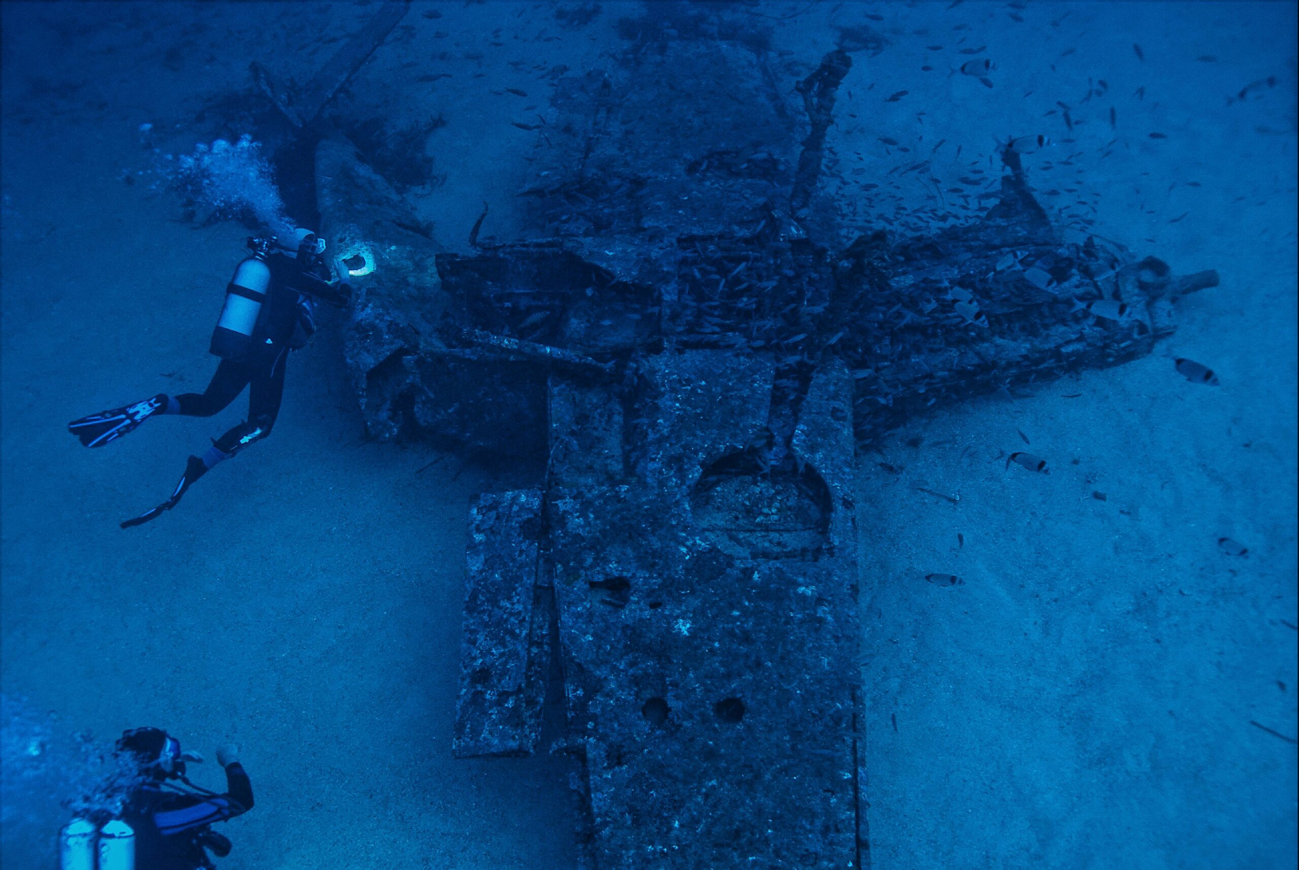
Perhaps nowhere has underwater photogrammetry made a more dramatic impact than in maritime archaeology. Ancient shipwrecks, submerged cities, and underwater artifacts that once required years of manual measurement and sketching can now be documented in days with millimeter-level precision. This speed doesn’t compromise quality—quite the opposite. The resulting 3D models capture details that human observers might miss, creating permanent digital records that researchers can study indefinitely without risking further degradation of fragile sites.
The Mediterranean Sea, with its thousands of years of maritime history, has become a showcase for these techniques. Projects documenting ancient Roman vessels, Bronze Age settlements, and medieval ports have generated unprecedented insights into historical trade routes, shipbuilding techniques, and daily life in antiquity. Researchers can now virtually “excavate” sites, analyzing artifact positions and relationships without disturbing the physical remains.
Preserving History Before It’s Lost
Time is not kind to underwater archaeological sites. Marine organisms colonize surfaces, currents shift sediments, and unfortunately, looters plunder valuable artifacts. Photogrammetric documentation creates permanent records that capture sites as they exist today, providing invaluable baseline data for monitoring degradation and planning conservation efforts. When physical artifacts are raised for study or preservation, their original context remains preserved in the digital realm.
This technology has proven particularly valuable in conflict zones and politically unstable regions where traditional excavation may be impossible or dangerous. Remote documentation allows researchers to study and preserve cultural heritage even when physical access is restricted, ensuring knowledge isn’t lost to political turmoil or warfare.
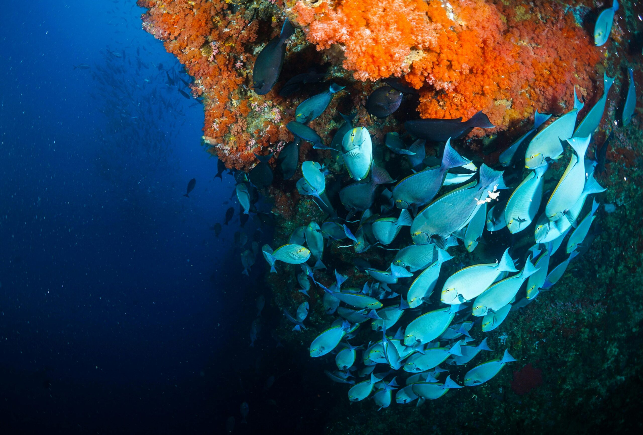
Transforming Coral Reef Monitoring and Conservation
Coral reefs, often called the rainforests of the sea, face unprecedented threats from climate change, ocean acidification, and human activity. Understanding the pace and patterns of reef degradation requires accurate, repeatable measurements over time—exactly what photogrammetry provides. Scientists can now create detailed 3D models of reef structures, documenting coral coverage, species distribution, and structural complexity with remarkable precision.
These baseline surveys enable researchers to return to the exact same locations months or years later, capturing new data that reveals changes with scientific rigor. The differences between surveys—coral bleaching events, storm damage, recovery, or continued decline—become quantifiable metrics rather than subjective observations. This data proves invaluable for assessing conservation interventions, predicting ecosystem trajectories, and communicating reef health status to policymakers and the public.
Measuring What Matters for Marine Ecosystems
Beyond simple documentation, photogrammetric models enable sophisticated analyses of reef health indicators. Researchers can calculate surface rugosity (three-dimensional complexity), a critical metric for biodiversity since structurally complex reefs support more species. They can measure coral growth rates, track individual colony health, and assess the success of reef restoration projects with unprecedented accuracy.
The technology scales remarkably well, from documenting individual coral colonies to mapping entire reef systems spanning kilometers. This flexibility allows researchers to investigate questions at multiple scales, from the cellular-level impacts of environmental stressors to landscape-level patterns in reef distribution and connectivity.
🚢 Infrastructure Inspection and Offshore Industry Applications
The offshore energy sector, shipping industry, and coastal infrastructure managers have rapidly adopted underwater photogrammetry for inspection and maintenance applications. Oil platforms, ship hulls, pipelines, bridge pilings, and harbor structures all require regular inspection to ensure safety and operational integrity. Traditional inspection methods often rely on expensive saturation diving or remotely operated vehicles with limited documentation capabilities.
Photogrammetric surveys provide comprehensive visual records that engineers can analyze in detail from the comfort of their offices. Corrosion patterns, structural deformations, marine growth accumulation, and damage assessment become straightforward when working with accurate 3D models. The ability to precisely measure features allows maintenance to be scheduled based on actual degradation rates rather than conservative assumptions, optimizing both safety and cost-efficiency.
Reducing Risk While Improving Quality
Every dive carries inherent risks, particularly in the deep or contaminated waters often associated with industrial infrastructure. By maximizing the information gathered during each dive and enabling remote analysis of comprehensive 3D data, photogrammetry reduces the number of dives required. This directly translates to improved safety outcomes and reduced operational costs.
Insurance companies and regulatory agencies increasingly recognize the value of detailed photogrammetric documentation. Comprehensive baseline surveys and regular monitoring provide evidence of proper maintenance and can prove invaluable in accident investigations or liability disputes.
Essential Techniques for Successful Underwater Photogrammetry
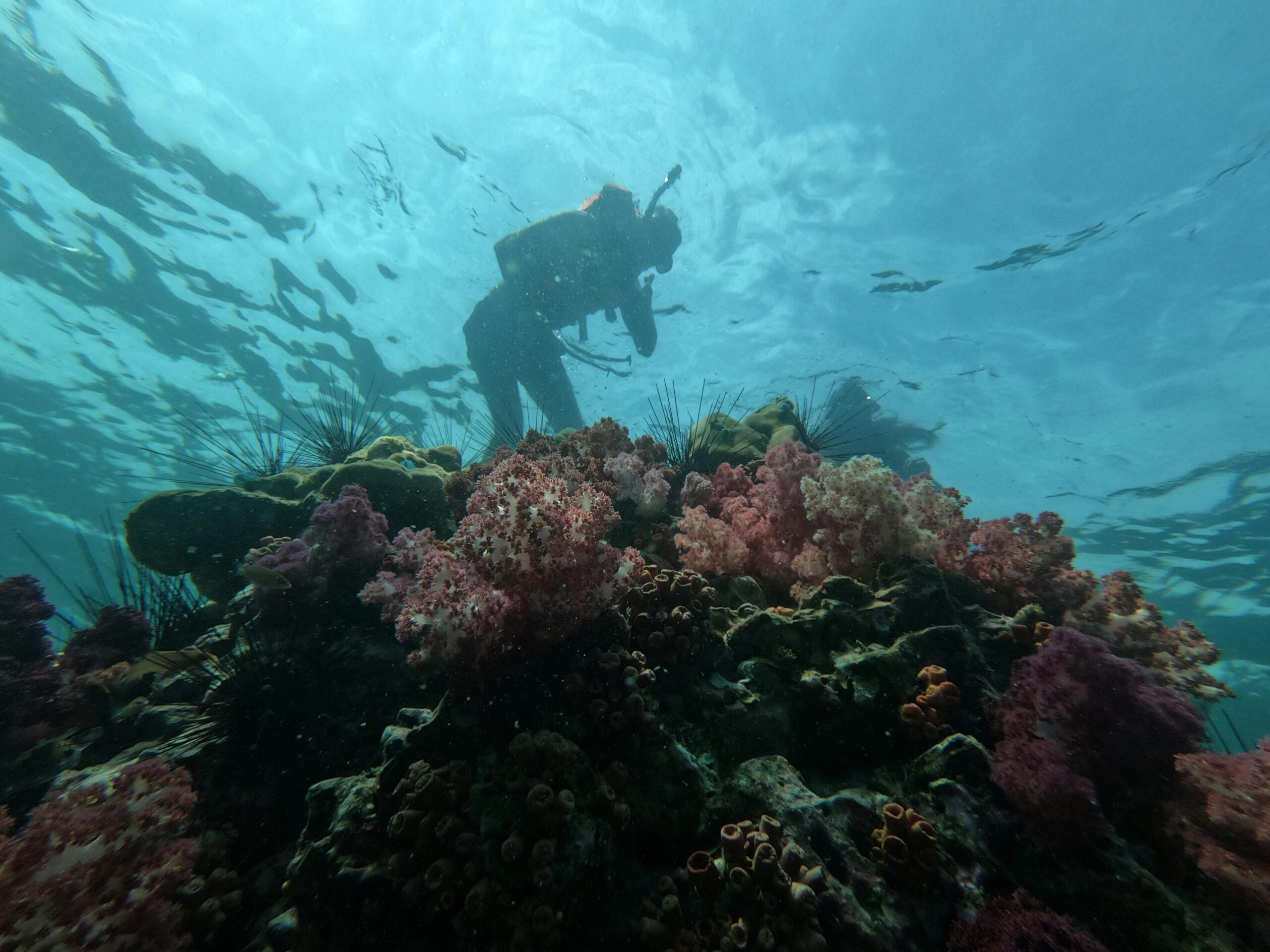
Achieving high-quality results requires mastering several key techniques adapted specifically for the underwater environment. Planning begins before entering the water, with researchers considering lighting conditions, water clarity, current strength, and subject characteristics. The survey pattern—how the photographer moves around the subject—critically affects model completeness and accuracy.
Successful surveys typically involve capturing images in systematic patterns with 60-80% overlap between consecutive photos. This redundancy ensures the software has sufficient common points to accurately reconstruct geometry. Photographers must maintain relatively consistent distances from the subject and avoid rapid movements that might introduce blur or inconsistent scaling.
Lighting Strategies for Accurate Color and Detail
Proper lighting separates amateur underwater photogrammetry from professional-grade results. External strobes or continuous LED lights restore colors absorbed by water, enabling accurate color reproduction in final models. Light positioning requires careful consideration to minimize shadows while avoiding direct reflections that can confuse photogrammetric software.
For large-scale surveys in clear tropical waters, natural sunlight may suffice, particularly in shallow depths. However, most professional applications benefit from controlled artificial lighting that ensures consistent illumination across the entire survey area regardless of ambient conditions or time of day.
Software Solutions Powering the Analysis 💻
The raw images captured underwater represent only the first step. Specialized software transforms these photographs into accurate, measurable 3D models through complex computational workflows. Several professional photogrammetry packages have emerged as industry standards, each with particular strengths for different applications.
These programs typically follow similar workflows: importing and organizing images, detecting and matching features across photos, calculating camera positions and orientations, generating dense point clouds representing three-dimensional surfaces, creating polygon meshes that define object geometry, and finally applying photographic textures to produce realistic visualizations.
Processing requirements can be substantial, particularly for large datasets. A single coral reef survey might generate thousands of high-resolution images requiring days of processing on powerful computers. Cloud-based processing solutions increasingly handle these computational demands, allowing researchers to focus on data collection rather than managing computing infrastructure.
From Point Clouds to Actionable Information
The 3D models produced by photogrammetry software become platforms for various analyses depending on project goals. Archaeologists create orthophotographs—geometrically corrected images suitable for precise measurements and mapping. Marine biologists calculate surface areas, volumes, and structural complexity metrics. Engineers generate detailed inspection reports highlighting areas of concern.
Integration with Geographic Information Systems (GIS) allows photogrammetric data to be combined with other spatial datasets, enabling sophisticated spatial analyses and long-term monitoring programs. Virtual reality applications bring underwater sites to the public, supporting education and outreach initiatives that would be impossible with traditional documentation methods.
Overcoming Common Challenges in Aquatic Environments 🐠
Despite its transformative potential, underwater photogrammetry presents challenges that practitioners must understand and address. Water clarity tops the list—suspended particles scatter light and reduce visibility, limiting the distances from which useful photographs can be captured. Planktonic blooms, sediment disturbance, or runoff from storms can render photogrammetry temporarily impossible in affected areas.
Moving water creates additional complications. Currents can make maintaining stable camera positions difficult, particularly for divers. Subjects themselves may move—fish certainly won’t pose patiently, and even supposedly stationary corals and kelp sway with water movement. These dynamics require faster shutter speeds to freeze motion, which in turn demand more powerful lighting or higher camera sensitivities.
Calibration and Accuracy Considerations
Water’s refractive effects require specific calibration procedures that differ from terrestrial photogrammetry. Underwater camera calibration typically involves photographing calibration targets underwater rather than in air, accounting for the actual optical conditions during data collection. Different water types—freshwater versus saltwater, clear versus turbid—may require separate calibrations for optimal accuracy.
Scale establishment presents another challenge. While terrestrial surveys can use GPS or laser rangefinders, these technologies generally don’t work underwater. Alternatives include placing scale bars of known dimensions within the scene, using parallel lasers to project known distances, or employing acoustic positioning systems for large-scale surveys.
The Future of Underwater Documentation Technology
Emerging technologies promise to address current limitations while expanding photogrammetry’s capabilities. Artificial intelligence and machine learning algorithms increasingly automate image processing, classification, and feature extraction. AI can identify specific coral species, count fish populations, or detect anomalies in infrastructure inspections, transforming photogrammetric models into rich databases of environmental information.
Miniaturization and cost reduction make advanced equipment accessible to smaller research teams and citizen scientists. Consumer-grade action cameras, when properly calibrated and deployed, can produce surprisingly accurate results for many applications. This democratization of technology accelerates data collection globally, particularly in understudied regions lacking well-funded research institutions.
Autonomous systems represent perhaps the most significant frontier. Underwater drones equipped with photogrammetry systems can survey depths and durations impossible for human divers. Machine learning enables these platforms to autonomously plan optimal survey patterns, adjust to changing conditions, and even make real-time decisions about which features warrant detailed documentation.
🎯 Getting Started with Underwater Photogrammetry Projects
Organizations and individuals interested in implementing underwater photogrammetry should begin with clear objectives. What specific questions need answering? What level of accuracy suffices? What resources—budget, personnel, equipment—are available? These fundamental considerations guide equipment selection, methodology development, and workflow planning.
Starting small allows teams to develop skills and refine techniques before undertaking major projects. Documenting a single small wreck or reef patch provides hands-on experience with the entire workflow, from dive planning through final model production. Online communities, workshops, and collaborative projects offer valuable learning opportunities and access to experienced practitioners willing to share knowledge.
Investment requirements vary dramatically depending on project scope and accuracy requirements. Basic setups using existing cameras and free software can produce useful results for many applications. Professional-grade systems with specialized cameras, lighting, positioning equipment, and commercial software represent substantial investments but deliver the accuracy and reliability essential for scientific research and industrial applications.
Ethical Considerations and Data Stewardship
As with any powerful technology, underwater photogrammetry raises important ethical questions. Archaeological sites, particularly those containing human remains, demand respectful treatment and often legal protection. Researchers must navigate complex webs of national laws, international treaties, and ethical guidelines governing underwater cultural heritage.
Data sharing and archiving practices deserve careful consideration. Photogrammetric models contain enormous amounts of information valuable to multiple disciplines and future researchers. Proper archiving ensures this data remains accessible and useful for decades. However, detailed models of archaeological sites might also guide looters to valuable artifacts, requiring thoughtful access controls balancing openness with protection.
The environmental impact of surveys themselves, though typically minimal, merits attention. Repeated diver visits can damage fragile ecosystems. Photographers must avoid touching or disturbing subjects, maintain proper buoyancy control, and minimize their physical footprint. The goal is documentation without disturbance, preserving sites for future generations while gathering the data needed for their protection.
Empowering Conservation Through Precision Measurement 🌏
Ultimately, underwater photogrammetry’s greatest contribution may be empowering evidence-based conservation and management of marine resources. Accurate baseline data and long-term monitoring provide the foundation for adaptive management strategies that respond to actual observed changes rather than assumptions or anecdotes. When conservation interventions are implemented, photogrammetric monitoring quantifies their effectiveness with scientific rigor.
The technology also bridges the gap between underwater environments and public awareness. Most people will never dive, yet photogrammetric models bring underwater sites into classrooms, museums, and living rooms worldwide. This accessibility fosters emotional connections and public support for marine conservation that abstract statistics cannot achieve.
As climate change accelerates and human pressures on marine ecosystems intensify, the need for comprehensive, accurate underwater documentation has never been greater. Photogrammetry provides the tools to document what exists today, monitor how it changes tomorrow, and hopefully, guide actions that preserve these irreplaceable environments for future generations. The precision revolution happening beneath the waves represents not just technological advancement, but hope for understanding and protecting the vast blue frontier that sustains all life on Earth.

Toni Santos is a maritime researcher and underwater archaeologist specializing in the study of submerged heritage, ancient port systems, and the cultural landscapes preserved beneath the sea. Through an interdisciplinary and immersive approach, Toni investigates how humanity has left traces of knowledge, commerce, and legend in the underwater world — across oceans, myths, and sunken cities.
His work is grounded in a fascination with wrecks not only as artifacts, but as carriers of hidden meaning. From historic shipwreck discoveries to mythical harbors and lost coastal settlements, Toni uncovers the physical and cultural evidence through which civilizations preserved their relationship with the maritime unknown.
With a background in marine archaeology and underwater survey methods, Toni blends technical analysis with archival research to reveal how oceans were used to shape identity, transmit memory, and encode sacred knowledge.
As the creative mind behind revaltro, Toni curates documented dive studies, speculative harbor maps, and archaeological interpretations that revive the deep cultural ties between water, folklore, and forgotten science.
His work is a tribute to:
The submerged heritage of Historic Shipwrecks and Their Cargoes
The legendary sites of Mythical Harbors and Lost Civilizations
The technical methods of Underwater Exploration Techniques
The natural archiving power of Preservation in Salt and Sediment
Whether you’re a maritime historian, nautical researcher, or curious explorer of forgotten submerged worlds, Toni invites you to explore the hidden depths of oceanic heritage — one wreck, one harbor, one legend at a time.